7 to 9 leaves open, due to strong growth through May 19, resulting from dry weather with daytime highs ranging 66 to 87F. Growth has slowed since May 20 due to rain and temps in the mid-50s to low-60s. The vineyard is in good shape; with nice, uniform shoot development. We've been able to get the first mowing and cultivating done, and the shoots have been tucked between the first set of wires. The current forecast shows the last week of May warming up into the mid-70s and drying out.
Thursday, May 24, 2012
Shoots Above 1st Wire, Growth Slowing due to Cool, Wet Weather
7 to 9 leaves open, due to strong growth through May 19, resulting from dry weather with daytime highs ranging 66 to 87F. Growth has slowed since May 20 due to rain and temps in the mid-50s to low-60s. The vineyard is in good shape; with nice, uniform shoot development. We've been able to get the first mowing and cultivating done, and the shoots have been tucked between the first set of wires. The current forecast shows the last week of May warming up into the mid-70s and drying out.
Friday, May 11, 2012
Dodged The Frost Bullet, Vineyard Is Looking Good
No frost last night. The vineyard is looking good; and we are having great Springtime weather, which we haven't had for the past couple years.
We pulled doubles and removed suckers over the past few days. Shoots are 3 to 6 inches long, four leaves open, with inflorescences exposed; and continued strong and even development throughout the vineyard.
115 Clone
Wadenswil Clone
Pommard Clone
114 Clone
Our 6.5 acres of newly planted vines are also off to a strong start; some of the vines are already beginning to peek out of the tops of the growtubes.
The forecast for the next 10 days shows dry and clear conditions, with temps reaching the mid- to upper-80s this weekend then cooling into the upper-60s to low-70s.
Thursday, May 10, 2012
Light Frost Last Night, But No Apparent Damage
Another beautiful Oregon Spring day ahead, frost forecasted for tonight, again.
HAZARDOUS WEATHER OUTLOOK
NATIONAL WEATHER SERVICE PORTLAND OR
336 AM PDT THU MAY 10 2012

ORZ001>010-012-014-WAZ020-022-023-039-040-111400-
NORTH OREGON COAST-CENTRAL OREGON COAST-
COAST RANGE OF NORTHWEST OREGON-
CENTRAL COAST RANGE OF WESTERN OREGON-LOWER COLUMBIA-
GREATER PORTLAND METRO AREA-CENTRAL WILLAMETTE VALLEY-
SOUTH WILLAMETTE VALLEY-WESTERN COLUMBIA RIVER GORGE-
NORTHERN OREGON CASCADE FOOTHILLS-
CASCADE FOOTHILLS IN LANE COUNTY-UPPER HOOD RIVER VALLEY-
WILLAPA HILLS-I-5 CORRIDOR IN COWLITZ COUNTY-
GREATER VANCOUVER AREA-SOUTH WASHINGTON CASCADE FOOTHILLS-
336 AM PDT THU MAY 10 2012

THIS HAZARDOUS WEATHER OUTLOOK IS FOR PORTIONS OF NORTHWEST
OREGON AND SOUTHWEST WASHINGTON.

.DAY ONE...TODAY AND TONIGHT

AREAS OF FROST ARE EXPECTED EARLY THIS MORNING AND AGAIN LATE
TONIGHT...ESPECIALLY FOR OUTLYING AREAS. SEE NPWPQR FOR MORE DETAILS.

.DAYS TWO THROUGH SEVEN...FRIDAY THROUGH WEDNESDAY

NO HAZARDOUS WEATHER IS EXPECTED AT THIS TIME.
Wednesday, May 9, 2012
Frost Advisory
URGENT - WEATHER MESSAGE...UPDATED
NATIONAL WEATHER SERVICE PORTLAND OR
136 PM PDT WED MAY 9 2012

...CHILLY NIGHT IN STORE FOR SOUTHWEST WASHINGTON AND NORTHWEST
OREGON TONIGHT...

.COOL HIGH PRESSURE FROM THE GULF OF ALASKA IS SETTLING INTO THE
PACIFIC NORTHWEST...BRINGING AN UNSEASONABLE CHILL TO THE AIR FOR
EARLY MAY. SKIES WILL CLEAR IN MOST AREAS SHORTLY AFTER SUNSET.
THE CLEAR SKIES AND LIGHT WINDS WILL PROVIDE OPTIMAL CONDITIONS
FOR COOLING OVERNIGHT. RECORD COOL TEMPERATURES ARE POSSIBLE...
AS TEMPERATURES WILL LIKELY APPROACH THE FREEZING MARK OVERNIGHT
IN THE OUTLYING VALLEYS AWAY FROM METROPOLITAN CENTERS.
Sunday, May 6, 2012
Shoots About 2-4 Inches Long, Great Weather Forecasted
Today was an absolutely beautiful day, weatherwise. After a 10-day stretch of below normal temps and showers, today we're near 70 without a cloud in the sky and great weather forecasted for the next 10 days.
Thursday, May 3, 2012
April 2012 Rainfall & Heating Degree Days
Rainfall during April was 3.08", slightly more than 0.5" higher than "normal"; cumulative rainfall since October (used to measure our "water year") was 38.95", almost 6" higher than "normal".
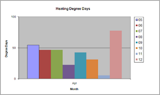
We had 77 Heating Degree Days {[(Daily High Temp + Daily Low Temp)/2]-51} during April, almost 2/3s of this occurring within a 5-day period (4/21 - 4/25) shortly after budbreak. This is the most Heating Degree Days during April in recent years, and led to a strong and uniform budbreak throughout our vineyard.
We had 77 Heating Degree Days {[(Daily High Temp + Daily Low Temp)/2]-51} during April, almost 2/3s of this occurring within a 5-day period (4/21 - 4/25) shortly after budbreak. This is the most Heating Degree Days during April in recent years, and led to a strong and uniform budbreak throughout our vineyard.
Subscribe to:
Posts (Atom)


